The role of GIS in the smart water platform
The smart water service platform is a set of water supply products based on the organizational structure, business processes and operation management of the water company. Through the establishment of a unique data center, the platform highly integrates, analyzes and applies multi-source heterogeneous data such as geographic information asset data, online monitoring data, warehousing data, revenue data, OA office data, water company hotline data, and realizes the integration of water company operation, intensive data management and control, efficient integrated dispatching, and scientific operation management. Micro service architecture design is adopted to provide data sharing service interface for water department and relevant departments.
Geographic Information System of Water Supply Pipe Network
Integrate various independent and decentralized asset information such as water source, source pipe, water plant, water meter, valve, water supply pipe, fire hydrant, booster pump, etc., and conduct data display and management through a unified platform to form a water supply asset data lifecycle management model based on basic geographic data, providing data support for water companies to sort out assets and related project planning.
Water Supply Comprehensive Application Department
Based on geographic information data such as high-precision digital elevation model, high-resolution image, urban water supply pipe network data, a set of visual management system integrated with water supply business of water supply company is constructed. Based on pipe network data, it provides services such as visual query, management and update of data related to integrated water supply business. On this basis, it realizes the management of the process and result data of the pipe network project, provides services such as pipe network maintenance and emergency repair, and greatly improves the operation and management efficiency of the water company.
Water supply metering management system
Rely on water meter, pressure and other IoT sensing equipment, reasonably carry out GIS zoning, reasonably analyze and calculate the data of IoT equipment through big data analysis, and find possible water leakage and leakage points. By collecting the data of the tax system, the system realizes the display and analysis of the data related to water supply and use in various regions.

Water supply pipe network detection, maintenance and emergency repair system
Based on the refined geographic information data, the tasks in the multi task system are aggregated to realize the standardization of work order information and task allocation. Through this system, the automation of line patrol and emergency repair personnel scheduling, as well as the transparency of the process of emergency repair and line patrol can be realized. Combined with the completion of tasks, the standardization of assessment is realized, which provides a good basis for employee assessment. The statistical analysis and chart display of different tasks can easily understand the progress of tasks in each region and provide a basis for the optimization of personnel organization structure.
BI system
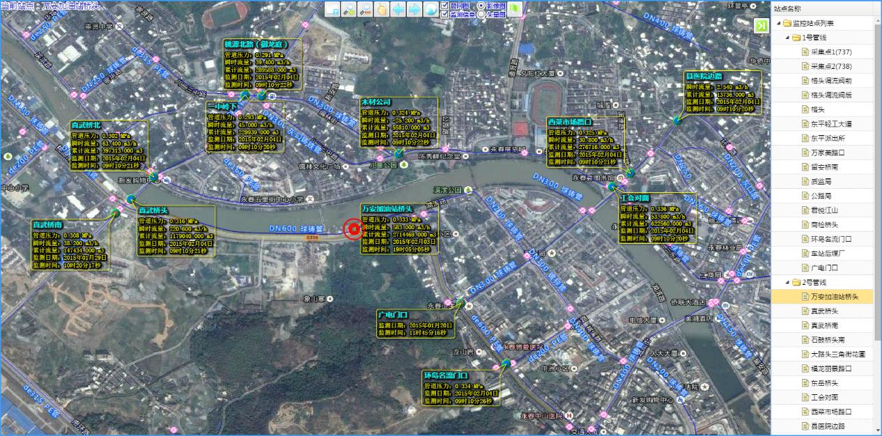
Rely on the data warehouse to gather multi system data and realize various rich displays of data in the data center. On the GIS basic platform, access the real-time monitoring data of front-end sensor equipment and control system, realize one-stop management, maintenance, expansion and access of geographic information and real-time monitoring (SCADA) of pipe network equipment, display and analyze various data with rich chart analysis tools, and give full play to geographic information system With the combination and linkage of real-time monitoring and business processing in space and time, Z supports the multi-dimensional and one-stop system use needs of water affairs to a large extent.
As an important basic supporting data of digital China, geographic information combines advanced technologies such as the Internet of Things and big data. Through the construction of intelligent water affairs integrated enterprise management and business operation platform, integration of data management standards, integration of comprehensive information display, simulation dispatching real-time science, and standardized and efficient operation management, the water affairs management decision-making and application service level of water enterprises has been effectively improved. In addition, GIS has many applications in the field of smart water supply. It is necessary to constantly develop the application value of geographic information to help the process of smart city construction.


